Click here to go back to the previous chapter
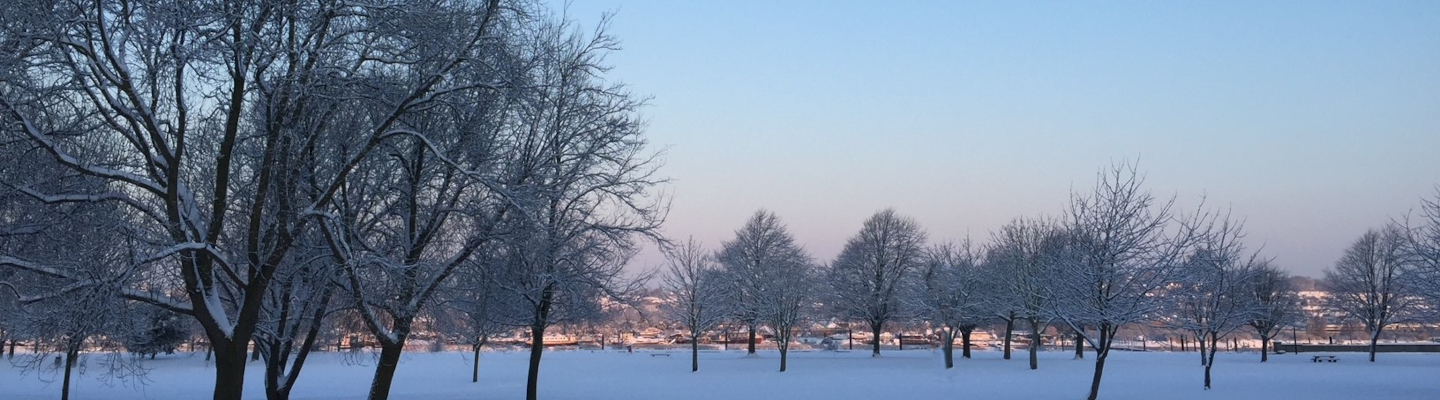
When I rose a little later than the previous morning, I knew I was paying a price for the 10-mile hike over uneven territory from my aching knees and a certain amount of hip flexor pain from what my body had clearly decided was over-use!! The discomfort wasn’t severe enough to need pain killers, but I thought I’d pop some paracetamol in my pocket just in case…
Over a breakfast of fresh fruit salad and a freshly baked croissants, I was relieved to learn that today was going to be a drive out to the ‘Badlands’. I was warned to wear long trousers and boots as the area was home to rattlesnakes, which can grow to nearly 2m long, and scorpions. I rather liked the word ‘Badlands’, and my mind conjured up scenes from old Western B-movies with cowboys on horseback galloping frantically across wide open prairies. This imaginary scene had no doubt been triggered by advertising seen at the airport on my arrival for the Calgary Stampede, an annual ten-day rodeo, festival, and exhibition celebrating the traditions of the ‘Old West’ and attracting over a million visitors each year.
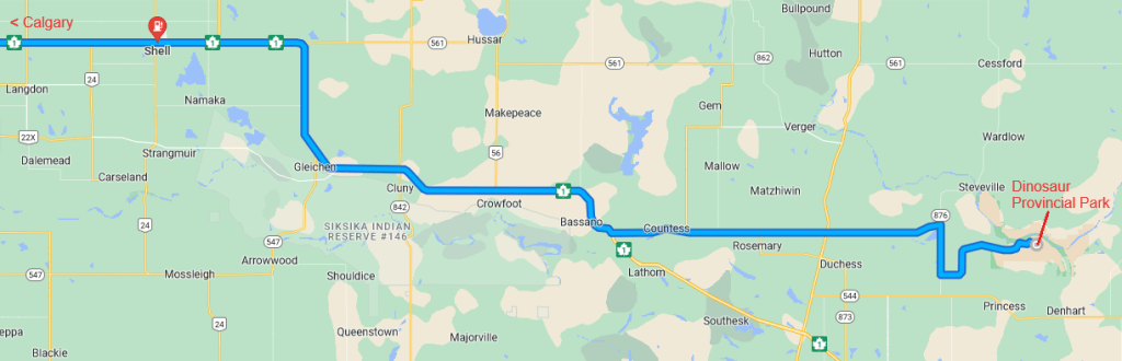
As it was to be a long drive, we set off in the Lexus, a more practical but still powerful and sporty car, with a hard top, air conditioning, and an automatic gearbox. The Trans-Canada Highway is just a minute or two’s drive from the house, and we joined the eastbound carriageway. Within an hour or so we reached the Calgary suburbs and headed towards the town centre. The city of Calgary is centred on the confluence of the Bow and Elbow rivers and is surrounded by modern one or two-storey residential developments which seem to stretch for miles across gentle hills and valleys. The downtown central business district is a cluster of glass and steel high-rise office towers along the South bank of the Bow River, very reminiscent of London’s Canary Wharf district on the banks of the Thames. Along the major roads, but protected from motorised traffic, is an extensive network of multi-use pathways shared by pedestrians, joggers, cyclists, and other green modes of transport. Generally, on a quick pass through in a car, it looks to be a well laid out modern city and I would be interested to explore more, but that will have to wait for a future visit.
Having passed through the centre of Calgary, we picked up the freeway again and the countryside began to open out in front of us. It was a lush green and pancake-flat in all directions, with the almost-empty road stretching for miles in a perfectly straight line into the distance. After another hour or so, the road inexplicably sweeps 90 degrees right and we were heading south, then 10 minutes later, the road turned left, and we were back heading east again.
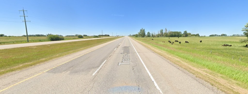
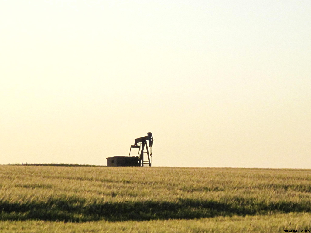
After a couple of hours of grasslands, with or without cattle, and wheatfields bisected by the occasional creek, the novelty of the prairie starts to wear off as there’s little to see apart from a scattering of ‘nodding-donkey’ oil pumps. Some were working away leisurely nodding backwards and forwards as they pumped oil or gas from the ground below, but others appear derelict. I was surprised and saddened to learn that, once the oil well has ceased to produce and been abandoned, there is currently no obligation on the oil company to decommission the defunct pump and restore the site to its original state.
Every now and again, we passed a traditional ranch with the entrance marked with two upright poles and a crosspiece at the top with a longhorn skull nailed at the centre, with a classic red barn and other low buildings in the distance. Some of these ranches have been farmed by members of the same family for generations and many continue to use traditional farming methods aiming for stress-free handling of their animals resulting in better quality beef. I was surprised to learn that most ranchers avoid heavy machinery and still use horses to move cattle between summer and winter pastures, or to gather the cows and calves at branding time. Many of these are ranches are home to several thousand head of cattle who spend their entire lives on the property. These farming families are often larger than average, and a couple of adults and their older children working as a team can manage several thousand acres, with each member taking different responsibilities either around the house or out riding the range.
Although some ranches have the facility to slaughter and prepare their own beef for the luxury market using traditional butchery techniques, most of the meat reared locally passes through a huge slaughterhouse near the town of Brooks towards which we were heading. The factory, owned by the world’s largest meat processing company, employs more than 3,000 workers, and slaughters several million cattle a year, but has a long and troubled history of staffing issues and labour shortages. Traditionally, the plant relied heavily on temporary foreign labour and recent immigrants to Canada as, although the job was dangerous and difficult, no language or literacy skills, nor special training were required. The work was grim, with staff spending long hours on refrigerated production lines cutting and packing meat, and the physical effort of disassembling thousands of animals into saleable parts took its toll on many of the workers. More recently, the factory owners have invested in heavily automated modern meat processing methods, which are monitored by video and audited remotely, for both food- and worker-safety reasons.
We left the freeway on the outskirts of Brooks after about three hours driving and headed North-East along local roads. The land is split into regular lots each about a mile square with a small road running between each like a giant grid. JM, who had worked as a GP in Brooks for about 30 years before retirement, told me how easy it was to become lost amongst these flat and featureless backroads with no landmarks of any kind for reference and no satellite navigation system. Fortunately, our route was well signposted, so we took another three or four right-angle turns onto ever decreasing roads as the scenery transformed from farmland to desert.
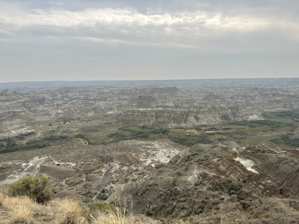
Suddenly, the ground seemed to fall away to reveal a sunken landscape featuring a spectacular valley network of deep, narrow, and winding canyons and gullies known as ‘coulees’, and large areas of rock that have been weathered into strange shapes and noted by early settlers to be ‘bad lands’ to cross.
We stopped at the viewpoint car park at the top and although it was a little hazy there was a fantastic view of the valley below. I’d probably been sitting down for too long and it was an effort to get out of the car, so I surreptitiously took the two paracetamol I had hidden in my pocket.
The photos below were taking from the same spot, one looking west back across the prairie we had just passed through, then I turned around to capture the dramatic landscape of the Badlands below.
(Click on an image below to view full size)
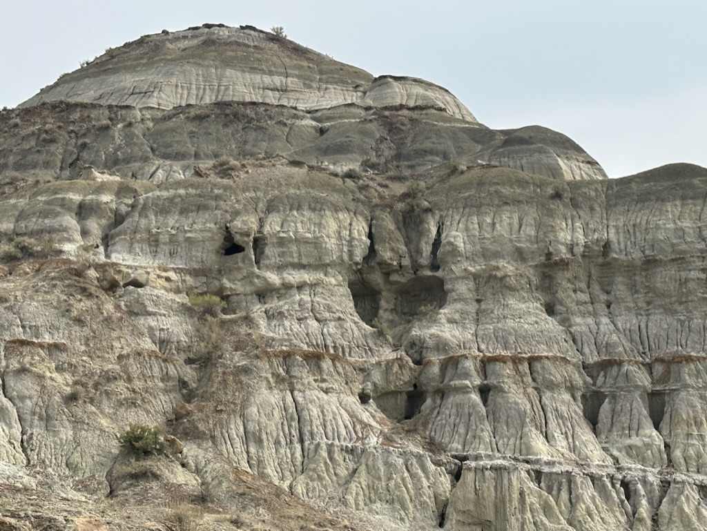
We then drove down into the Badlands and arrived at the Dinosaur Provincial Park, a UNESCO World Heritage Site which is home of some of the most impressive dinosaur fossils ever discovered. Over 500 specimens from nearly 60 different dinosaur species have been found so far in this 7,825-hectare (30 square-mile) park and removed to be placed on display in museums around the world. The Park is home to a large camping ground, picnic area, several walking trails, and a loop-road with 2 outdoor fossil displays. There is also an excellent Visitor Centre with museum, theatre, and of course a gift shop.
In the Visitors Centre I learned that around 75 million years ago, Alberta was a sub-tropical paradise filled with lush forests at the edge of a large shallow sea, and home to fish, amphibians, reptiles, birds, primitive mammals and about 35 species of dinosaur. When the animals died, some of them fell into river channels and mud flats so their bones were buried with new layers of sand and mud. Over thousands of years, a combination of pressure, lack of oxygen and deposition of minerals turned them into fossils, then new layers of sediments covered these fossils preserving them almost in perpetuity.
I also learned that the Badlands were created by natural forces, ‘only’ about 13,000 years ago when they were formed by glacial meltwater pouring through arid or semi-arid regions of weak and relatively loose sedimentary rocks exposing them to an erosion process and washing away huge areas of land. The territory continues to change from wind and rainwater which often falls in short, torrential thunderstorms.
Once I’d walked around a bit, and the paracetamol had done their stuff, I felt much better. I am sure that if I had felt a little less sore from the previous day, I might have felt more adventurous, but was quite relieved that we only walked a few kilometres along trails in the park looking at some of the fantastic rock formations. Fortunately, we didn’t come across any rattlesnakes nor scorpions, although I did see a couple of huge bald eagles soaring high above searching for something nice to eat.
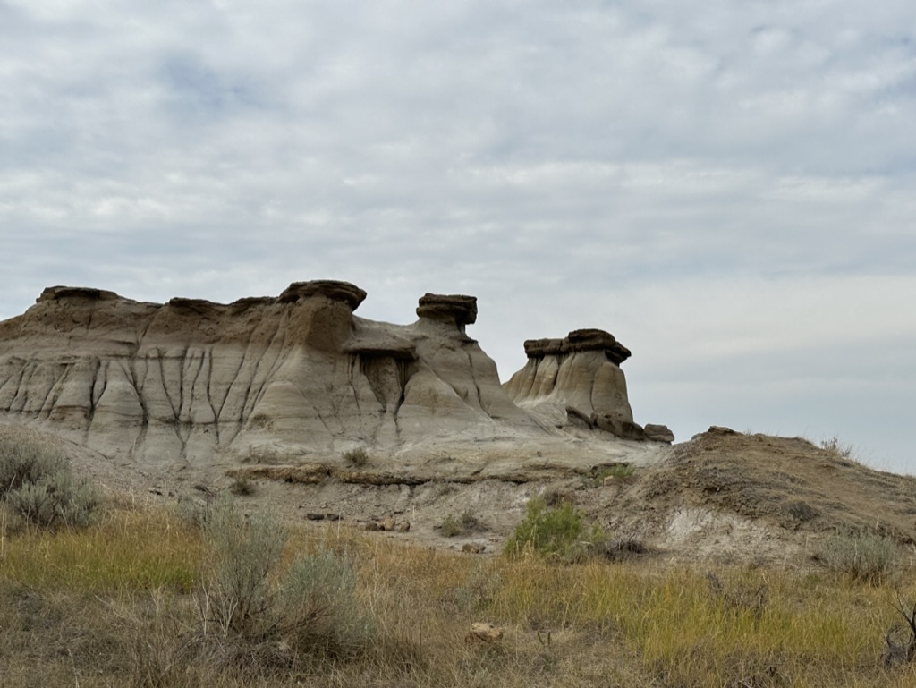
One of the iconic features of the Badlands are ‘hoodos’, which are fantastically shaped sandstone pillars usually around 5 to 7m high (15 to 21ft) resting on a thick base of shale and capped by a large stone. These are very fragile and, if the capstone is dislodged the sandstone below can quickly erode completely. The Badlands is an incredibly atmospheric place and it’s no exaggeration to say it felt like being on another planet.
After exploring the Park for a couple of hours, it was my turn to drive, and I was guided south to the tiny hamlet of Patricia a few kilometres away. After bumping along a dusty track for a while, we passed a herd of the most magnificent horses I have ever seen. These appeared to adult mares and some foals, and their coats ranged from dark solid colours to the beautiful Pinto combinations of colours and markings so typical of ‘cowboy’ horses.
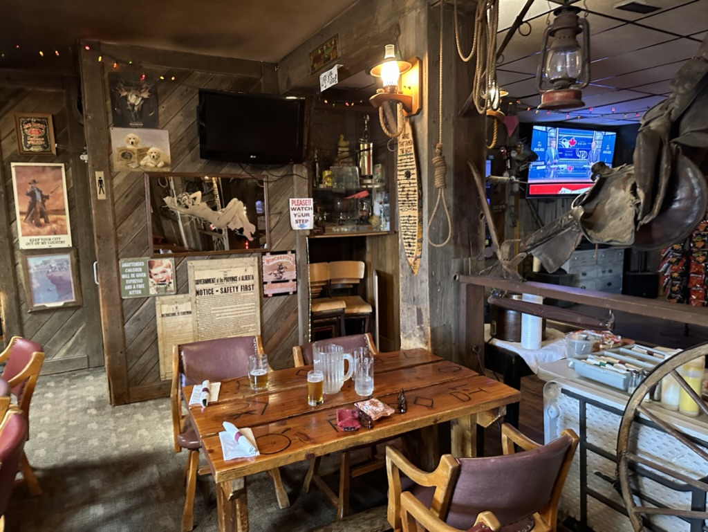
Patricia is a rural community of fewer than 80 inhabitants, and we pulled up outside the imaginatively named Patricia Hotel for a late lunch. There were red painted hitching posts outside for horses, and a home-made ‘Welcome’ sign made from lasso rope on a wooden board hanging over the ancient saloon swing-doors which lead into the bar.
Dating back to 1915, the hotel boasts an ancient wooden structure that has undergone multiple extensions throughout the years. Inside, the walls are constructed from salvaged materials sourced from old barns and stables, and the tables, also made from recycled wood, bear the distinctive marks of local brands burned into their surface.
The bar and dining areas are adorned with an array of quirky Plains memorabilia and old-school taxidermy, and country music plays quietly in the background. The other patrons had seemingly been plucked from a rural farming scene and there was definitely a slight aroma of livestock, with several flies lazily circling the air completing the rustic feel.
I know, as a firefighter and health and safety expert, my late brother Nick would consider this establishment a complete death-trap as diners cook their own food on a couple of huge gas barbecues at the back of the dining area (fortunately with an extractor vent above). Having ordered from a limited menu, I was a little taken aback to be handed a paper plate on which rested some raw meat wrapped in greased paper, a part-cooked jacket potato, and a thick slice of white bread spread with garlic butter for toasting. A selection of the biggest ears of corn in their husks that I have ever seen rested in a plastic bucket of water on the floor, and complimentary accompaniments including home-made soup, salad, and condiments were available on a table nearby.
I chose my corn and placed it with the potato on the grill, along with a ‘bacon wrapped tenderloin’, which consisted of two fillet mignon steaks each about 30mm thick wrapped with a couple of slices of bacon around the outside and a long wooden skewer joining the two in a -OO- format. I had no idea how long I should cook the food for, but JM advised me to cook for five minutes on each side, then another two minutes each side before adding the bread for the last minute or two of cooking, then piling everything back onto the paper plate and heading back to our table.
The experience was quite surreal, but the food was superb! Frankly, I’m not a big meat eater, but this was easily the best steak I’ve ever tasted. Although it was slightly underdone for my usual preference (seared on the outside but still ‘bleu’ in the centre), it had a mild flavour, absolutely no fat or marbling, and the melt-in-the-mouth texture was reminiscent of top-quality smoked salmon. Quite frankly, it was amazing. I had heard that Canadians consider local Alberta beef to be the best in the world, and it’s hard not to agree.
After our lunch, we hit the road again and I drove the 350km or so back to Canmore.
The Lexus is a delight to drive and boasts an array of impressive driver assistance features which take a lot of the effort out of long journeys. These include adaptive cruise control, lane departure warning and blind spot sensors. While it falls short of full self-driving capabilities, the cruise control is an electronic system that automatically manages the car’s speed, relieving the driver from constantly pressing the accelerator pedal.
To use this feature, the driver simply sets a maximum speed, and the car automatically maintains a safe following distance from any car in front. If the gap narrows too much, the system reduces speed accordingly, however a simple flick of the indicator causes to the card to resume its original speed, allowing for a smooth overtaking manoeuvre, provide of course the driver has checked the road is clear. I have used similar in the UK, but the traffic is generally so dense that it is barely useable, but on the wide-open Canadian freeway it performed exceptionally well.
One potential issue to bear in mind when driving long distances in Canada, is the risk of running out of fuel. Despite Canada is the second biggest country in the world, fuel stations can be few and far between, often leaving hundreds of kilometres between each one! For example, the nearest filling station along the Trans-Canada Highway to the Dinosaur Provincial Park was nearly 200km away – about half a tank’s worth of fuel – so we filled up on the way out, then again on the way back again to ensure the car didn’t run dry.
All in all, the Trans-Canada Highway, despite some noticeable cracks on the carriageway in the prairie regions, offers a better road surface than most UK motorways, making long-distance drives in Canada comparatively easy. It’s almost impossible to imagine making a 700km (435 mile) day trip in the UK – the equivalent of driving from London to York and back again in a single day – but the vast distances and open roads of the Canadian prairie region make this sort of journey much more feasible and pleasant.
Click here to read the next chapter…
[i] From Google Maps
[ii] Wikimedia image used under Creative Commons licence
[iii] From Google Maps
